GEOPoint 3.03
This application helps you manipulate the satellite antena.
GEOPoint is a fast and reliable satellite antenna pointing calculator, for geostationary communications satellites. It calculates the azimuth and elevation pointing angles from a given location on the earth towards a specified geostationary satellite.
GEOPoint can also calculate polarisation tilt angles, eirp and frequency stability, antenna G/T estimate dates and times of annual sun-outage events, and estimate path-loss and rain-attenuation based on ITU-R climate models. As used by Hausfeld Consulting for satellite communications planning.
· An easy to use dialog-style user interface for data entry and calculation;
· Entry of earth station location coordinates directly, or by clicking on a world map;
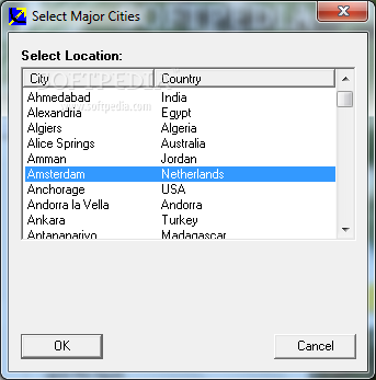
· Select earth station location from a built-in list of world major cities;
· Display of satellite elevation contours on the world map to aid in site selection;
· Entry of latitude and longitude coordinates in d,m,s format, or as decimal degrees;
· Calculation of pointing angles to a specified satellite for common types of antenna mount;
· Display of azimuth pointing angles relative to True North, and relative to local magnetic north;
· Estimation of antenna movement limits for inclined orbit satellites;
· Calculation of polarisation tilt angle, loop-back path delay, and required antenna tracking speeds;
· Estimation of the peak dates and times for sun-interference on the receive link.
· Output of a summary report in HTML format.
Limitations:
· The following features are not available:
· Ability to zoom the world map one level for more accurate site selection;
· Ability to save the current map image to file.
· Estimation of site altitude from ITU-R world topography model;
· Select earth station location from a user supplied file containing a list of sites;
· View and save a diagram of the GEO Arc visible from the site;
· Labelling of individual satellites and plotting local horizon and antenna movement limits;
· Plotting of satellite locations from Norad two-line element or Intelsat ephemeris format orbit data;
· Display of ITU-R Climate Model data for the specified earth station location;
· Estimate antenna G/T from user inputs of antenna parameters and frequency;
· Calculate path loss between the earth station and satellite at a specified frequency using ITU-R propagation models;
· Estimate the impact of satellite motion on EIRP and frequency stability;
· Output a batch report of pointing angles from the site, for a list of user selected satellites;
· Output a detailed report of sun interference dates and times for given receive antenna parameters;
· Output a detailed report of rain attenuation loss for a range of frequencies and link availability;
· Output a batch summary report for a list of earth station sites.
What’s New in This Release:
Basic Features (Free):
· Upgraded to the latest World Magnetic Model (WMM2010) for calculation of magnetic azimuth (compass direction).
· New check box on the Map window to allow users to enable or disable display of a lat,long grid on the map.
· New Tool to allow the user to select a location from a built-in list of world major cities.
Advanced Features (requires Registration):
· Added extra map movement buttons on Map Window when zoomed.
· New item in Tool menu, allows user to select a location from a user supplied site list file.
· New tab in GEOArc View Options to allow the user to change fonts on the plot.
· New Track menu on the GEOArc allows users to load satellite orbit data from a file in two-line elements format, or 11 parameter ephemeris format, and plot the orbit on the GEOArc.
· After completing GEOArc batch plots, the program now announces completion and reports the number of images saved.
· After completing a TLE File Sort, the program now announces completion and reports th…